ShelfMap is back its following its hibernation during Covid-19.
It now features a floorplan Editor as well as numerous bug fixes and enhancements which have been worked on in the last couple of years. Highlights include:
The new Editor – Amend your plans and re-publish them at your convenience. Keep backups of old versions.
Automatic optimisation of plan size and position to suit the device being used.
Clickability – click furniture to see what books it contains
Better highlighting. The stack itself can be highlighted in addition to (or instead of) the usual pin or arrow
Grouping of stacks – several stacks can be designated as containing a certain
Due to Covid-19, ShelfMap is self-isolating, rather like the rest of us. As so many libraries are closed to the majority of users and with safety measures preventing them from accessing book stacks, there seems little point in running the servers at the moment.
However, it is planned to re-launch later in 2021 when we have more idea about when libraries will be open. It will be very interesting to see how library services develop in the light of the pandemic and whether it leads to higher demand for self-service technology solutions so watch this space.
When producing an indoor map, the first thing the user wants to know is where they are located within the space. This is not as easy as it might sound to achieve. GPS is the standard technology for locating the position of a mobile device, but it doesn’t necessarily work all that reliably indoors. In the library context, if you were in the basement of a 10 storey concrete building, all that mass is going to be likely to weaken or even eradicate the signal. So how else might this be achieved?
Starting with lo-tech solutions, you could simply attach QR codes to particular places where people will be travelling along such as stairways, corridors etc. The user would scan one of these which would deliver information to the wayfinding App which resolves their current location. Another method might be to use the barcodes in books on the basis that one barcode has a relationship (via the LMS) to another. There would need to be some interaction between the wayfinding App and the LMS web services for this to work. For example, one stack which is associated with one call number range and a map location would be could be resolvable by matching this from the source barcode to its item call number. Both these methods suffer somewhat from requiring a participatory approach from the end user – they need to find and scan something first.
More hi-tech routes have also been experimented with. Using wifi wireless access points within the library to triangulate a user’s position is one. This requires the MAC address of each device to be databased and mapped. There is also the possibility of using bluetooth beacons which can be dispersed in hard to reach areas. Most of the systems available make some sort of attempt to use a hybrid approach with one or more of these technologies, including GPS. An additional problem for libraries is that stacks and books tend to be fairly dense materials leading to lots of opportunities for blind spots where the user is in effect, hidden from view. The precision is also something which would need to be determined. The sort of system I have just described works quite well in a shopping mall setting where the user wants to find a specific shop. Finding a book, or even a stack amongst many is a different kettle of fish. Having said this, there are technologies being developed and it would be great to experiment with one in a library to see just how far it has come.
As part of the Masters research into wayfinding carried out by the ShelfMap developer, an astonishing 13,582 views of ShelfMap from the catalogue were clocked up over a three-month period. Solid evidence that this is a service which library users want to have available.
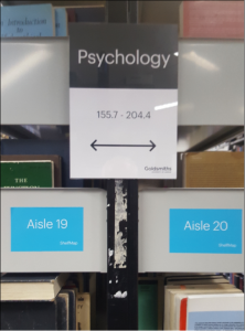
Aisle signs with ShelfMap were an effective combination
Research carried out by the developer of ShelfMap as part of his Masters by Research at Manchester Metropolitan University has indicated that students experience reduced anxiety in using the library if they have access to a wayfinding tool.
As part of the research at Goldsmith’s Library, six students were asked to find four items – two without any wayfinding assistance, and two using ShelfMap. A time saving of 39% to find the correct stack was observed when using ShelfMap.
Comments made by the participants using ShelfMap included:
“I would have identified the book [in task 3] a lot quicker [if using ShelfMap].”
“Look, I’m whizzing through”
Another observation was that using companion signage (stack side numbers) in conjunction with ShelfMap boosted navigational success in a way that signage in itself could not.